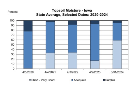
Much of the state experienced cooler than normal temperatures and much needed rain/snow showers which left Iowa farmers with 1.6 days suitable for fieldwork during the week ending March 31, 2024, according to the USDA, National Agricultural Statistics Service. Although minimal fieldwork occurred over the last week, some producers were able to apply anhydrous, manure, and dry fertilizer.
Topsoil moisture conditions improved with late winter rain. Conditions statewide rated 22 percent very short, 37 percent short, 37 percent adequate and 4 percent surplus. Topsoil moisture in west central Iowa rated 17 percent very short, 28 percent short, 52 percent adequate and 3 percent surplus.

Subsoil moisture condition statewide rated 35 percent very short, 41 percent short, 22 percent adequate and 2 percent surplus. Subsoil moisture in west central Iowa rated 21 percent very short, 56 percent short, 22 percent adequate and 1 percent surplus.
Oats seeding has already reached 21 percent complete, 11 days ahead of both last year and the 5-year average. Much of the seeding took place prior to the week ending March 31. Some seeding took place several weeks ago and is starting to emerge.
No reports of cattle turned out onto pasture yet as many pastures are just beginning to green up with little new growth. Calving was in full swing.
Weather Summary – provided by Justin Glisan, Ph.D., state climatologist, Iowa Department of Agriculture and Land Stewardship – An active storm track brought unseasonably wet conditions to Iowa’s northwestern two-thirds, leading to widespread improvement in drought conditions. Temperatures during the first reporting period of 2024 varied from cooler conditions in the northwest to marginal warmth in the southeast; the statewide average temperature was 40.2 degrees, 2.3 degrees cooler than normal.
Several waves of showers and a few thunderstorms continued across Iowa Sunday, March 24, during the afternoon and evening with east-southeasterly winds. Daytime highs ranged from the mid-30s north to low 50s south, where periodic peaks of sun were observed. A southerly shift in the wind occurred overnight as the large-scale, low-pressure center pushed into western Iowa. Muddy rain was reported on Monday morning as a large dust plume from New Mexico was lofted into the atmosphere and transported northeast via the mid-level steering flow. A dry slot with minimal cloud cover formed in the early afternoon allowing highs to rise into the low 60s across central and southern Iowa. Showers and thunderstorms reformed in southeastern Iowa and then across a broader area in western Iowa through the remainder of the day.
The low-pressure center finally exited Iowa early Tuesday, March 26, with some snowflakes flying as colder air wrapped in behind the system. Event rain totals were well above average for most locations with more than140 stations collecting at least an inch in Iowa’s northwestern half; more than one-third of the stations in west central to northwest Iowa measured 2.00 to 3.00 inches with 3.05 inches in Jefferson (Greene County). Strong northwesterly winds developed in the afternoon with mid 20s northwest to mid-30s southeast under overcast skies. Clouds gradually cleared west to east before sunrise on Wednesday, with morning lows in the teens under clear skies and in the mid-20s farther east where stratus clouds were present. Unseasonable cool afternoon temperatures held in the 30s with westerly winds.
Partly cloudy skies persisted into Thursday morning, March 28, as light winds became variable with temperatures across western Iowa in the 20s to low 30s southeast. Winds shifted to the east through the daylight hours with temperatures reaching into the upper 60s in the southwest counties while conditions were up to 25 degrees cooler to the northeast. Spotty and light showers developed in eastern Iowa with several stations picking up a trace of rainfall; Muscatine (Muscatine County) measured 0.12 inch.
Morning temperatures Friday were in the 30s as persistent easterly winds gained strength. A warm front lifted north into the state as winds shifted to the south in advance of a low-pressure system approaching Iowa. Highs reached into the mid-70s south of the front while conditions held in the upper 50s in northern Iowa. Isolated strong to severe storms fired in eastern Iowa after sunset. Stations that received rain generally reported less than 0.20 inch, though locations under heavier storms observed totals ranging from 0.56 inch in Dubuque (Dubuque County) to 0.79 inch in Hopkinton (Delaware County). Saturday, March 30, was somewhat of a chilly day with clear skies, gusty northerly winds and temperatures in the low 40s northwest to low 60s southeast. Overcast conditions developed into Sunday morning with low temperatures dropping into the upper 30s across northern Iowa.
Weekly precipitation totals ranged from 0.03 inch in Moulton (Davis County) to 3.11 inches in Eagle Grove (Wright County). The statewide weekly average precipitation was 1.20 inches, almost double the normal of 0.64 inch. Shenandoah (Page County) reported the week’s high temperature of 76 degrees on March 29, 18 degrees warmer than average. Primghar (O’Brien County) and Sibley (Osceola County) reported the week’s low temperature of nine degrees on March 27, on average 19 degrees cooler than normal. Four-inch soil temperatures ranged from the low 40s north to upper 40s south as of Sunday.
