The USDA National Agricultural Statistics Service released its first Iowa crop progress and condition report for the 2022 growing season. The report is released weekly April through November.
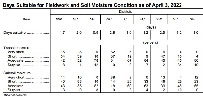
Crop report – Precipitation and cold conditions limited Iowa farmers to 1.6 days suitable for fieldwork during the week ending April 3, according to the USDA, National Agricultural Statistics Service. When and where possible, fieldwork activities included applying anhydrous and fertilizer, spreading manure and planting oats.
Statewide, topsoil moisture levels rated 9 percent very short, 25 percent short, 58 percent adequate and 8 percent surplus.
West central Iowa is the driest of the nine reporting areas in the state, with only 31 percent of the soil moisture test sites reporting adequate levels. Thirty-two percent reported very short topsoil moisture levels and 32 percent report the level to be short.

Subsoil moisture levels across the state rated 12 percent very short, 35 percent short, 49 percent adequate and 4 percent surplus. In west central Iowa, only 18 percent of the test sites reported adequate subsoil moisture.
Pastures were still mostly dormant. Livestock conditions were generally good although feedlots were wet after the week’s rain. Producers report calving is continuing.
Weather summary provided by Justin Glisan, Ph.D., state climatologist, Iowa Department of Agriculture and Land Stewardship – Unseasonably cold temperatures blanketed the state over the first reporting period of 2022 with negative departures of up to nine degrees in northwestern Iowa; the statewide average temperature was 36.1 degrees, 7.3 degrees colder than normal. Wetter than average conditions were reported in eastern Iowa, while precipitation deficits of up to 0.50 inch were measured in the southwest.
Northerly winds persisted through Sunday afternoon, March 27, as cloud cover increased in southwestern Iowa. Daytime high temperatures were unseasonably cool with 30s and 40s reported northeast to southwest; these readings were 10 to 15 degrees colder than normal. Overnight lows into Monday morning varied from the upper teens in eastern Iowa to low 30s in the west. Winds shifted to an easterly direction as a dome of high pressure pushed into the Great Lakes region through the afternoon hours with temperatures rebounding into the mid to upper 40s under mostly sunny skies.
Overcast conditions developed early Tuesday, March 29, as gusty southeasterly winds built in ahead of a strong low pressure center pushing into Nebraska. As a warm front lifted over southern Iowa, high temperatures rose into the mid-60s while upper 30s and 40s were observed north of the boundary. A few severe thunderstorms formed during late evening hours in southwestern Iowa and with showers overnight into central and eastern Iowa. The system continued northeast into Wednesday morning as rain tapered off and gusty northerly winds returned. Event totals were highest across the state’s southeastern third with general amounts from 0.20 inch to 0.75 inch; three stations in extreme southeastern and northwestern Iowa measured over an inch with Chariton (Lucas County) observing 1.40 inches.
As cold air filtered in behind the low pressure system, snow showers formed over much of Iowa with most stations reporting light totals. Moderate snow fell across central Iowa with 2 to 3 inch accumulations measured at several stations; the statewide average snowfall was 0.8 inch with Indianola (Warren County) picking up 3.2 inches. Morning lows observed at 7 am on Thursday ranged from the upper 20s northwest to low 30s southeast, where snowflakes were still flying. Gloomy conditions persisted through the evening hours with highs hanging in the low 30s statewide, well below average for the last day of March.
Iowans woke up to starry skies and chilly conditions on Friday morning, April 1, though temperatures rose as southerly winds ushered in warmer air into the afternoon. Daytime highs registered in the upper 40s north to 50s west as cloud cover increased in advance of a fast moving disturbance that brought widespread rainfall to much of Iowa into early Saturday morning. Most of Iowa’s stations observed measurable precipitation, both liquid and frozen, with several locations picking up a few inches of snow; Dubuque Regional Airport (Dubuque County) measured 4.5 inches. Liquid-equivalent totals were in the range of 0.25 inch to 0.75 inch with Bellevue Lock and Dam (Jackson County) reporting 0.83 inch. Clear skies returned overnight into Sunday with lows at sunrise in the upper 20s and low 30s under variable winds.
Weekly precipitation totals ranged from 0.01 inch at Bedford (Taylor County) to 1.64 inches at Davenport Municipal Airport (Scott County). The statewide weekly average precipitation was 0.60 inch while the normal is 0.68 inch. Sioux City Airport (Woodbury County) reported the week’s high temperature of 67 degrees on March 29, 13 degrees above average. Algona (Kossuth County) reported the week’s low temperature of 11 degrees on April 1, which is 18 degrees below normal. Four-inch soil temperatures were in the upper 30s north to low 40s south as of Sunday.
