
 It was a cool dry week in Iowa during the week ending Sept. 3, according to USDA, National Agricultural Statistics Service. Statewide there were 6.2 days suitable for fieldwork. Activities for the week included haying, hauling grain, chopping corn silage, seeding cover crops, and harvesting seed corn.
Topsoil moisture levels statewide rated 13 percent very short, 27 percent short, 59 percent adequate and 1 percent surplus. Topsoil moisture levels in west central Iowa rated 1 percent very short, 12 percent short, 82 percent adequate and 5 percent surplus.
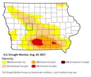 According to the Aug. 29, U.S. Drought Monitor, areas of south central and southeast Iowa have been in a severe drought for 5 consecutive weeks. All of Greene County is either in moderate drought or abnormally dry.
Subsoil moisture levels statewide rated 17 percent very short, 31 percent short, and 52 percent adequate. Levels in west central Iowa rated 7 percent very short, 36 percent short, and 57 percent adequate.
Ninety-four percent of the corn crop was in or beyond the dough stage, five days behind last year but three days ahead of the five-year average. Sixty percent of the corn crop has reached the dent stage, eight days behind last year and three days behind average. Corn condition rated 62 percent good to excellent.
Eighteen percent of soybeans have started to turn color, five days behind last year and three days behind average. Soybean condition improved to 61 percent good to excellent. There were scattered reports of disease issues in soybeans such as sudden death syndrome.
The third cutting of alfalfa hay reached 91 percent complete, eight days ahead of last year and more than two weeks ahead of average. Pasture condition rated 16 percent very poor, 23 percent poor, 35 percent fair, 24 percent good and 2 percent excellent. Cooler temperatures have been ideal for livestock; however, there were still reports of producers in south central and southeast Iowa feeding hay to cattle due to poor pasture conditions.
Iowa preliminary weather summary by Harry Hillaker, state climatologist, Iowa Department of Agriculture & Land Stewardship – It was a dry and unseasonably cool week across Iowa.
Temperatures were below normal throughout the week except at a few western Iowa locations. Monday, Aug. 28, and Friday, Sept. 1 were the coolest days in most areas with daytime highs in the 70s. Temperature extremes for the week ranged from Friday morning lows of 41 degrees at Cresco and Elkader to a Saturday, Sept. 2, afternoon high of 86 degrees at Albia.
Temperatures for the week as a whole averaged from four to seven degrees below normal over the east to slightly above normal in the far northwest with a statewide average of 3.0 degrees subnormal.
Most of the week’s rain came on Sunday when rain was scattered nearly statewide with some very small areas of heavy rain in the Dubuque and Burlington areas. There were some thunderstorms on Monday over extreme eastern Iowa, with some localized heavy rains around Burlington. There were some isolated showers on Thursday, Friday and Saturday, but with rain totals mostly under one-tenth of an inch.
Asbury in Dubuque County reported the most rain for the week with 3.31 inches while Burlington saw 2.72 inches. Much of central and south central Iowa saw little, if any rain.
The statewide average rainfall amount was 0.11 inches while normal for the week is 0.88 inches. This was the state’s driest week in 12 weeks (mid-June). At Fairfield the summer rainfall total (June-July-August) was only 3.51 inches. This was their lowest summer rain total among 137 years of records at that location (old record 3.77 inches in 1911). The Ottumwa airport recorded even less rain for the summer with 3.38 inches, but this amount ranked a distant second behind 1911’s 1.80 inch total at that location.